
Global Travel Information
Elbe River Drone Footage: Aerial Videos of the Waterway
The Elbe River from Above: A Journey Through Time and Tide
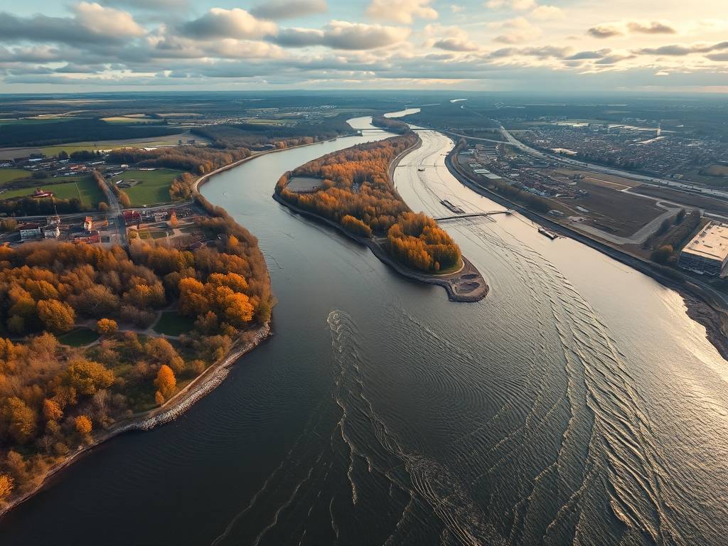
There's a unique magic to seeing a familiar landscape from a new perspective. The world flattens, patterns emerge, and a grand, sweeping narrative unfolds beneath you. This is precisely the experience offered by stunning Elbe River drone footage, which has opened up this historic European waterway in ways previously reserved for the birds. These aerial videos of the Elbe River are more than just pretty pictures; they are a dynamic, moving portrait of a river that is the lifeblood of Central Europe, telling stories of history, commerce, ecology, and breathtaking beauty.
")
For anyone curious about this majestic river—be it a potential traveler, a geography enthusiast, or someone simply seeking visual solace—this Elbe River aerial video guide aims to be your comprehensive resource. We'll explore what makes this drone footage of the Elbe so compelling, journeying from its source to its mouth, uncovering the hidden gems and grand vistas that only an aerial view can provide.

The Source: A Peaceful Beginning in the Czech Republic
Our aerial journey begins not with a roar, but with a whisper, in the rugged Krkonoše Mountains of the Czech Republic. Here, Elbe River drone footage captures the humble origins of this mighty river. The early shots are intimate: a small, clear stream trickling over mossy stones, surrounded by dense, evergreen forests. This scenic aerial view of the Elbe River source is a tranquil prelude, a reminder that even the greatest journeys start from modest beginnings. As the drone ascends, the stream coalesces into a defined watercourse, carving its path through the picturesque Czech countryside. The view from above reveals the river's initial meandering path through towns like Špindlerův Mlýn, a popular ski resort that takes on a completely different, verdant character in the summer months seen from the sky.
The Saxon Splendor: Castles, Gorges, and Dresden's Baroque Glory
As the river crosses into Germany, entering the region of Saxony, the landscape begins to dramatically shift. This is where Elbe River drone footage truly starts to showcase its versatility. The Saxon Switzerland National Park is a highlight, a realm of dramatic sandstone pillars, deep gorges, and lush forests. Aerial shots here are nothing short of epic. The drone swoops through the Bastei Bridge, a magnificent sandstone bridge perched precariously above the Elbe, offering breathtaking panoramic views of the Elbe River valley. The contrast between the rugged, weathered rock formations and the serene, green river below is a visual masterpiece.
Following the river northwest, the drone approaches the "Florence on the Elbe," the city of Dresden. The aerial view of Dresden's cityscape along the Elbe is a poignant tale of destruction and rebirth. The camera glides over the magnificent dome of the Frauenkirche, the sprawling complex of the Zwinger Palace, and the elegant Semper Opera House. From above, the meticulous reconstruction of the historic city center after World War II is laid bare, a testament to human resilience. The wide, graceful curve of the river as it flows past the Terrassenufer, the city's beautiful riverbank promenade, creates a perfect harmony between urban architecture and natural beauty. This segment of Elbe River drone footage is essential for understanding the cultural soul of the waterway.
The Heart of Germany: Meissen, Torgau, and the River's Flow
Continuing north, the river passes through towns steeped in history. A drone flight over Meissen reveals the iconic Albrechtsburg Castle and Meissen Cathedral standing sentinel on a hill high above the river, their spires dominating the skyline—a perfect subject for capturing the historic charm of the Elbe by drone. Further on, the town of Torgau holds immense historical significance; it was here that American and Soviet troops first met at the end of World War II. An aerial view of the Elbe Bridge in Torgau provides a powerful, silent commentary on this pivotal moment.
This stretch of the river is also characterized by its unique Elbe River valley landscapes. The drone's perspective reveals the river's intimate relationship with the land: sprawling meadows, quaint vineyards on sun-drenched slopes, and picturesque villages clustered along its banks. The Elbe River waterway aerial photography showcases the river's role as a vital transport corridor, with barges silently gliding along its surface, carrying goods from the Czech Republic to the North Sea. This is a fantastic example of how drone footage of the Elbe can seamlessly blend scenes of natural tranquility with those of modern industrial logistics.
The Hamburg Metropolis: Where the River Meets the World
Perhaps the most dramatic transformation in the entire journey is the approach to Hamburg. The serene river suddenly widens, morphing into a bustling, monumental port. Aerial videos of the Elbe River in Hamburg are a spectacle of scale and energy. The drone soars over the sprawling container terminals of the Port of Hamburg, where colossal ships are docked like floating cities, and colorful containers are stacked in neat, geometric blocks. This is a prime location for spectacular drone views of Hamburg's Elbe port.
The flight continues over the iconic Elbphilharmonie concert hall, its glass structure shimmering above an old brick warehouse, a stunning symbol of the city's blend of old and new. Crossing the Köhlbrand Bridge or circling the massive Airbus plant at Finkenwerder, where aircraft components are transported by ship, the drone captures the sheer industrial might of the Elbe. Yet, even here, nature persists. The aerial view reveals the vast mudflats of the UNESCO World Heritage Wadden Sea National Park at the river's estuary, where the freshwater of the Elbe finally mingles with the saltwater of the North Sea. This Hamburg Elbe River aerial perspective is a captivating study in contrasts.
A River for All Seasons: The Changing Face of the Elbe
One of the most beautiful aspects of Elbe River drone footage is its ability to document the river's changing moods throughout the year. A springtime flight captures the vibrant green of the riverbanks and the blossoming trees in the Elbe Meadows. A summer video shows the river alive with leisure activity—sailboats, cruise ships, and sunbathers on the beaches. Autumn brings a fiery palette of red, orange, and gold to the surrounding forests, creating a scenic aerial view of the Elbe River that is rich with warmth.
Even winter has its own stark beauty. On cold mornings, a low-hanging mist often blankets the river, through which the spires of castles and churches pierce dramatically. In rare, frosty conditions, the landscape can transform into a monochromatic wonderland. This seasonal variety ensures that exploring the Elbe River by drone video is a continually rewarding experience, offering new visual stories with every passing month.
In conclusion, the power of Elbe River drone footage lies in its comprehensive storytelling. It connects the dots from a tiny mountain stream to a global shipping artery. It unveils the hidden patterns of nature and the grand designs of human civilization, all from a vantage point that inspires awe and understanding. Whether you are planning a trip and seeking the best views, studying the geography of Central Europe, or simply wanting to embark on a virtual tour from the comfort of your home, these aerial videos offer an unparalleled journey. They are a testament to the fact that to truly know a river, sometimes you need to rise above it and see the whole magnificent story unfold beneath your wings.
相关文章
- Elbe River Virtual Tours: Explore from Home
- Elbe River 360-Degree Views: Immersive Online Experiences
- Elbe River Time-Lapse Videos: Watch the River Change Over Time
- Elbe River Documentaries: Learn About the River’s Story
- Elbe River TV Shows: Episodes Filmed Along the Banks
- Elbe River Podcasts: Listen to River-Related Content
- Elbe River Radio Stations: Local Music Near the Water
- Elbe River Newspapers: Local News Along the Banks
- Elbe River Magazines: Local Publications to Read
- Elbe River Blogs by Locals: Insider Tips from Residents
发表评论
评论列表
- 这篇文章还没有收到评论,赶紧来抢沙发吧~